Etonbury.
Arlesey.
Location
Grid Reference TL192379 Latitude 52.027216° Longitude -0.263076°
The The Historic Environment Record for Bedfordshire says:-
Summary
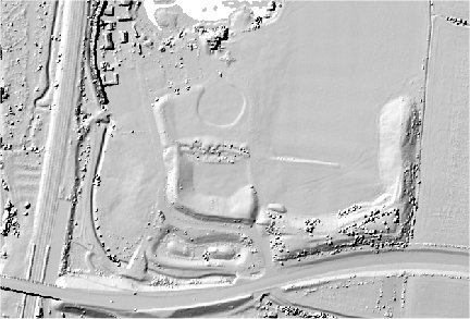
The remains of a complex of earthworks, damaged by railway, road and sewer pipe construction. The remains consist of a raised area to the south, with curving banks to the north and east. The raised area has been affected by the diversion of the Pix Brook through it and is now flat. It was irregular in shape, measuring approx 60m by 40m and approx 0.8m high, and surrounded by a dry moat-like feature with a causeway at the north east side. The site has been interpreted as a harbour and defences connected with the Danelaw frontier but there is no proof for this. It is most likely to be a manorial site, but possibly reusing earlier earthworks. A document of 1566 refers to "Etonsbury wherein sometyme was the scyte of the Mannor utterly decayed" and also to "Saynt Andrewes Chappell" there. The curving banks were sectioned by a sewage trench dug in 1972. Observations at the time showed that they were of gravel with a thick timber-laced clay core. Timber traces in the upper gravel layers suggest the presence of a palisade. The banks are bounded on the north and north east by ditches, the southern one being shown by the work in 1972 to be 1m deep. Only the eastern ends of the banks were still extant by 1987. On a ridge to the east of the banks are traces of a further earthwork, possibly manorial; it is rectangular, measuring approx 300m by 200m and bounded by the Pix Brook on the south and west. Most of it has now been ploughed out. Observations in 1972, and in 1986 when the Pix Brook was diverted, have resulted in finds of medieval pottery (mostly 12th-13th century) and animal bones. Metal objects thought to be Roman have been dated as much later but their functions are not known. Roman pottery has been found on the site, however, and also late Iron Age pottery and a small number of flint implements.
James Scott Petre says:-
A prime example of the difficulties we have with some sites when attempting to classify them. A hundred years ago, Goddard and Beauchamp Wadmore compared it to Willington, intimating that both were Anglo-Danish establish- ments rather than medieval moated sites as we now know Willington to be at least. In dismissing the Danish explanation for both sites and drawing attention to their similarities as medieval fishponds expanded by gravel quarrying, Baker thought that Etonbury was possibly a ringwork later adapted for non military manorial purposes. Cathcart King also took it to be a ringwork - with one or two baileys. Most recently, Lowerre renewed the comparison with Willington and that it was merely a medieval manorial complex from its inception. There seems little cause to contest this interpretation and that consequently we should accept that Etonbury, like other place names with the suffix -bury, was indeed a medieval, manorial site rather than a 'castle'.
2D LIDAR
3D LIDAR interactive
3d_rotation Left mouse button to rotate.
swap_horiz Right mouse button to pan.
swap_vert Centre scroll wheel to zoom.