Cainhoe Castle
Ancient Monument
About
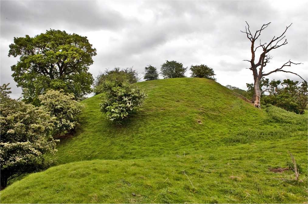
To the south of Clophill, across the Flitt valley, are the remains of a motte and bailey castle.
 Cainhoe Castle
It was probably built soon after the Norman Conquest. The large mound is the motte and the surrounding embankments enclose the baileys.
The site now has many Pedenculate Oak trees and Hawthorn bushes
Access
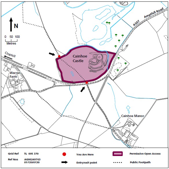
A Public Footpath starts in the High street opposite Town Shott and leads to the site. There is Permissive Access to the field which means you are free to explore.
 Permissive Access
Download a walk guide from Clophill Discovery Walks. Walk 5 takes you to Cainhoe Castle.
Location
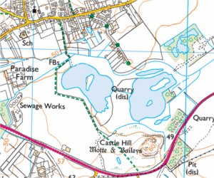
Cainhoe Castle is located outside the village of Clophill close to the A507 road.
 O.S. map
The site
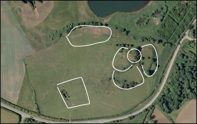
The white circle shows the position of the motte.
The first bailey is to the west of the motte.
The second and third baileys are to the south and east with an entrance between them.
The rectangle shows the possible position of a platform for a manor house which was built when the castle fell out of use.
To the north are a series of fish ponds which would have been used to hold fish as a fresh food source.
 Aerial photo
Aerial Photos
These photos were taken before the Fuller's Earth excavations started. In the first photo, looking north, the second and third baileys, with a possible entrance track between them, can be seen.
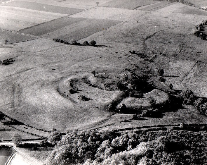 Aerial photo 1
In the second photo many surface irregularities can be seen. The rectangle in the foreground might have been the site of a manor house.
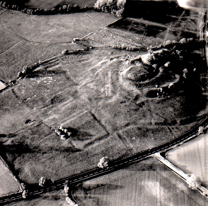 Aerial photo 2
LiDAR
LiDAR (Light Detection And Ranging) data is very accurate, high resolution 3D data. Captured using special sensors, from the air or the ground, it results in a set of "dots" suspended in a three-dimensional space. These dots can be displayed in special software or converted into a 3D mesh.
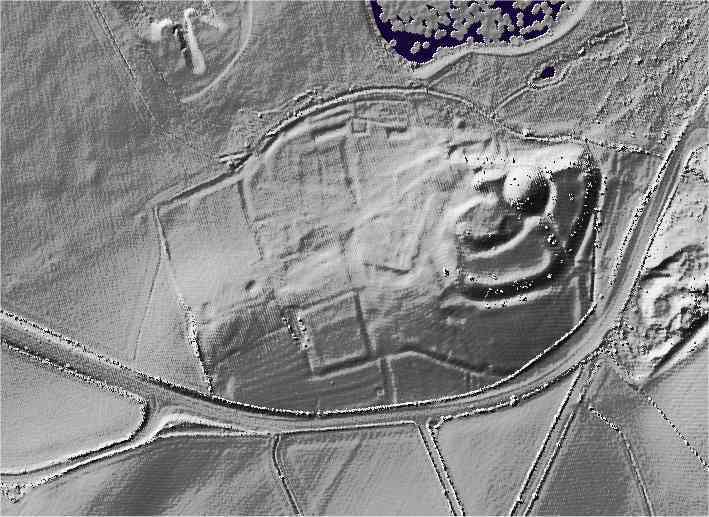 LiDAR
3D LIDAR interactive
3d_rotation Left mouse button to rotate.
swap_horiz Right mouse button to pan.
swap_vert Centre scroll wheel to zoom.
Click to open interactive 3D LIDAR in separate window
How it might have looked
Motte and Baileys
The sketch shows the arrangement of a typical early motte and bailey castle. The motte was the main refuge and means of defence. It has built by producing an artificial hill or making use of the natural topography, if it was suitable. On it was built a tower (or keep) to give more height and to further intimidate the native English.
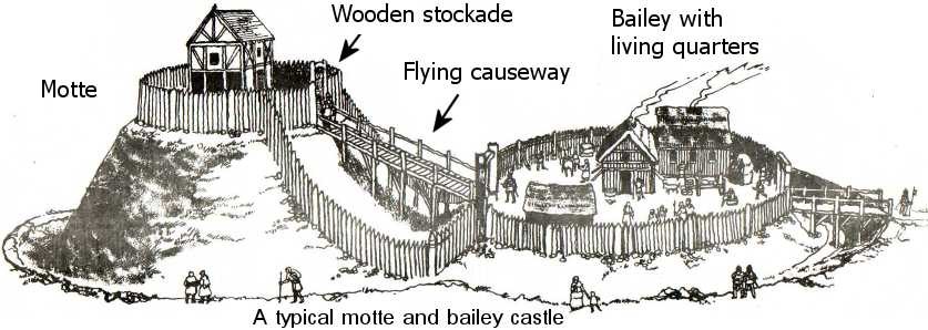
The bailey was a yard, surrounded by an embankment and ditch and provided a first line of protection. It contained barracks, stables, livestock and other buildings for storing food, weapons and equipment. If attacked the occupants could retreat to the motte.
The motte and bailey castle originated in Normandy. Several are depicted in the Bayeux Tapestry.
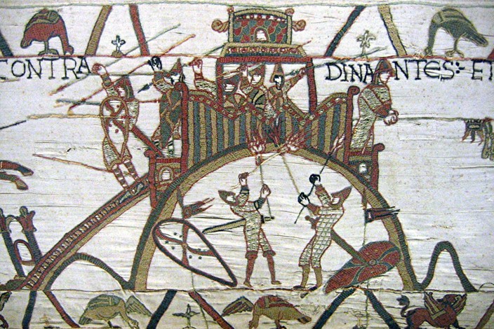 This part of the Bayeux Tapestry illustrates soldiers attacking the Motte of Chateau de Dinan in France, and setting fire to it - taking advantage of combustible timber.
Motte and Bailey castles could be built fairly rapidly with the minimum of tools. William needed to take control of the country quickly and the swift erection of a castle was a way of showing his authority.
The blue lines on the hachure map show the original shape of the castle. Bailey 1 has been subjected to quarrying at some time so a large part of the bank is missing.
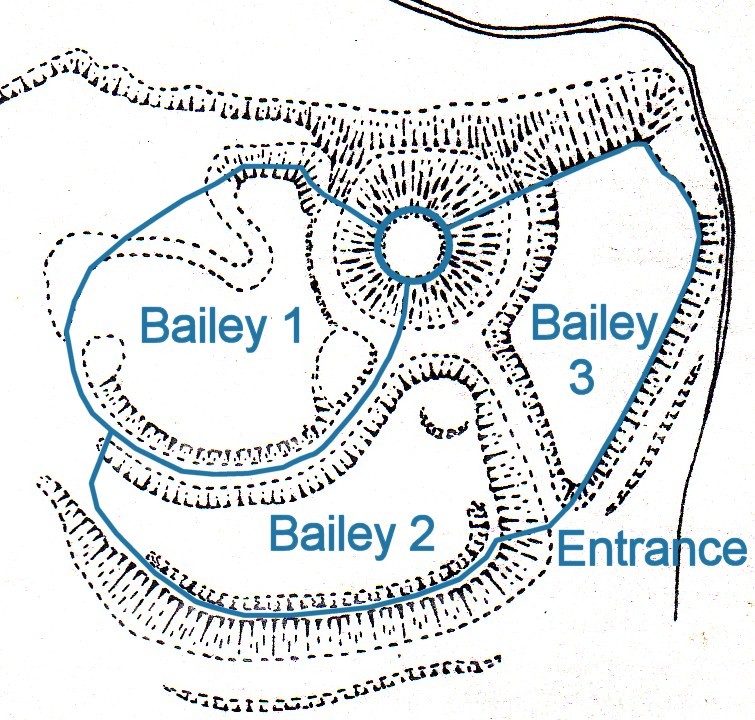 Hachure map
The site was chosen as the the natural topography was a spur with sloping ground on all sides, idealy suited for constructing a motte and bailey castle with the minimum of digging and earth moving.
Archaeological Investigations
Due to a road widening scheme, excavations were carried out in 1973 to find the archaeological nature of the anomalies to the south and east of the castle site, prior to their destruction.
The full report is in Bedfordshire Archaeological Journal Vol 10, 1975.
A series of trial trenches across the features were dug.
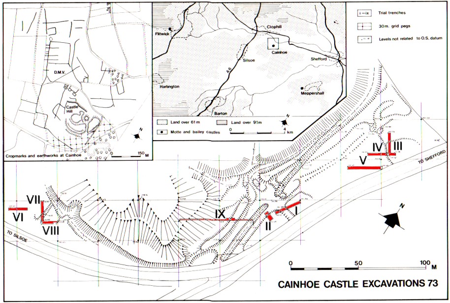 Hachure map
Relevant findings
The investigation was did not cover the whole site of the castle, just the area to the side that would be affected by the roadworks.
"Trench VI. No finds or features were found and it would seem that the hill was entirely natural."
This indicates that the site was chosen because its form was ideal for constructing a motte and bailey castle with the minimum of labour. The natural outcrop was used for the motte and baileys were constructed utilising the surrounding slopes.
"INTERPRETATION OF TRENCHES I AND II: The road orientated toward one of the Castle entrances seems to have had two periods of use, for the later road surface overlapped one of the two drainage ditches, which seem to have been deliberately filled-in. The pottery on the road surface, of local medieval manufacture (thirteenth century date), might indicate a contemporary date with the later phases of the Castle, but the shoes tend to indicate a rather later usage, at least for the second road surface."
So the baileys 2 and 3 may have been built at the same time with an entrance road between them.
Finds
Here are some extracts from the report describing the finds.
The Rondel Dagger
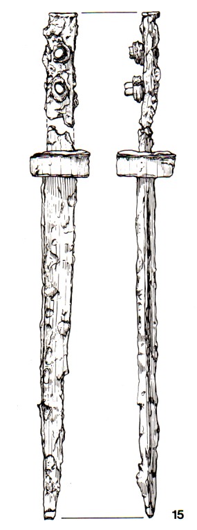 "An iron dagger was found in Trench Vl and is illustrated. Although broken, with a missing rivet and pommel, this single edged dagger has a cylindrical guard and the proportions of a rondel-type dagger of the mid-late fifteenth century. The rivets, with horn grips, indicate that the tang originally had a cover, probably of wood. This type of dagger was in common usage by both soldiers and civilians in the fifteenth century."
Wooden Stakes
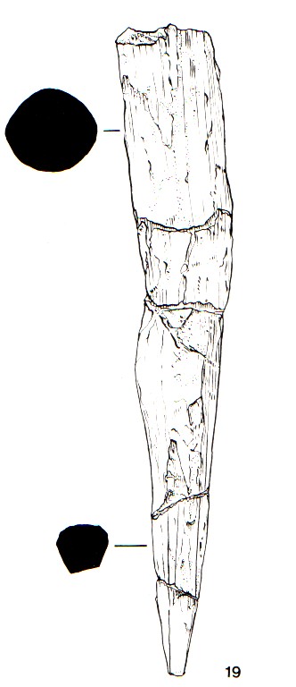 "... some thin sticks in a criss-cross pattern were preserved and might represent part of a collapsed wattle structure.
... these twigs could be associated with the preserved wooden stakes in trench IV of an earlier period which form quite definite structures.
The stakes in trench IV could be grouped into fence lines and corners, some having the remains of wattles lying between them.
A radio carbon date was obtained for stake 13 from Harwell; this was 1450 ± 70 years B.P. (B.P. - 1950) giving a date of 500 a.d. ± 70 years. The structure is therefore assumed to represent either some form of raised platform especially if the twigs in IV are directly related to it or possibly a seasonal animal pen in use when the depressed area was dry.
From an examination of the wood stakes, Richard Thomas has shown that there were six species present. This suggests that the timber was randomly selected and that the builders were perhaps cutting down undergrowth rather than using whole mature trees. This in turn suggests the building of a temporary structure for seasonal rather than permanent settlement."
Pottery
"A total of 93 sherds were collected. 78 of these were of local medieval manufacture and of thirteenth century form.
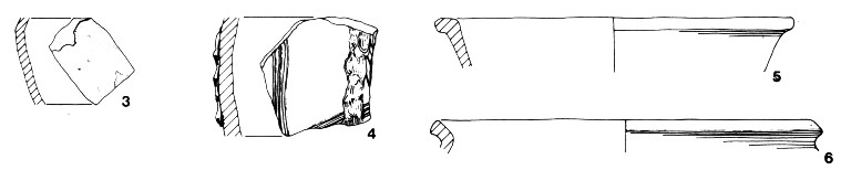
13 sherds had a soft soapy feel to them and were of an earlier medieval form. Of the 91 medieval sherds, 43 were a coarse surface gritty ware, 7 were sandyware, 27 were a gritty ware sometimes with a mica grit surface and l was a fine hard grey gritty ware. The remaining two sherds were of Roman form."
Flints
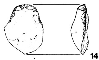 "A number of worked flints were found at Cainhoe. The origin of the material is probably the local gravel beds on the Ivel. A large number of the flakes were utilised and/or retouched including two thermal flakes (one of which has the status of a scraper tool and is illustrated)."
Horse Shoes
"Horseshoes and one oxshoe were found. The horseshoes and oxshoe found on the two road surfaces in trial trench I were very difficult to date as there were no typical characteristics.
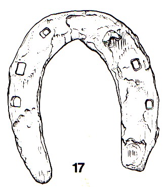 The oxshoe and horseshoe on the second road surface have some characteristics that indicate a medieval, post thirteenth century date: for example, the smooth edge and broad proportions and the slight upturning of the horseshoe at the rear for a calkin.
The horseshoe from trench VI must be later medieval or later, to judge by the fullerred groove between the nail holes, and the smooth outline."
Historical Sources
There is no direct mention of Cainhoe Castle in any historical records. Information about the castle has to be deduced from contemporary records.
Domesday book
The Domesday Book is a great land survey from 1086, commissioned by William the Conqueror to assess the extent of the land and resources being owned in England at the time, and the extent of the taxes he could raise.
Royal commissioners were sent out around England to collect and record the information from thousands of settlements.
There are two entries for Cainhoe as it was divided between two tenants; Nigel d'Albini, tenant-in-chief and Turstin, a sub-tenant of Azelina.
There is no mention of Cainhoe Castle. This may be because the castle did not generate any income and therefore could not be taxed or that it had not been built at the time of the inquest.
There could have been a community of about sixty or seventy people at Cainhoe.
Cainhoe 1
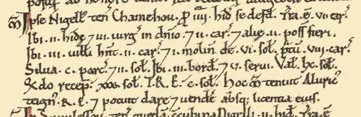 First entry in Domesday Book for Cainhoe.
"Nigel himself holds Cainhoe. It is assessed at 4 hides. There is land for 6 ploughs. There are 2 hides and 3 virgates in demesne, and 2 ploughs, and there can be 2 others. There 3 villans have 2 ploughs, and [there is] 1 mill rendering 6s, meadow for 8 ploughs, [and] woodland for 100 pigs and [rendering] 2s. There are 3 bordars and 5 slaves. It is worth 60s; when received, 30s; TRE 100s. Ælfric, a thegn of King Edward, held this manor and could give and sell it without his leave"
Cainhoe 2
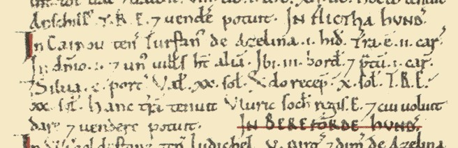 Second entry in Domesday Book for Cainhoe.
"In Cainhoe Turstin holds 1 hide of Azelina. There is land for 2 ploughs. In demesne [is] 1 [plough]; and 1 villans has another. There are 3 bordars, and meadow for 1 plough, and woodland for 100 pigs. It is worth 20s; when received, 10s; TRE 20s. Wulfric, a sokeman of King Edward, held this land and could give and sell it to whom he wished."
